UPDATES
9:00 am Israel time, Sunday, July 5 2015
**Remember yesterday’s blog about the supposedly 17 year old terrorist who was shot to death while he was committing terrorism? Do you also remember how the U.N. was quick to condemn Israel for killing “a Palestinian boy”?
Today we have a picture of that “boy”:

Mohammed Sami al-Ksbeh, a Palestinian “child”.
**In the neighborhood:
From Syria: IS “rebels” around Damascus have turned off the city’s water supply; on the other side, the Syrian Army reports that more than 100 IS fighters have been killed at Aleppo.
From Egypt: Egyptian border guards discovered more than half a ton of explosives being smuggled from Egypt into Gaza last night through a tunnel just south of the Rafah Crossing. In the meantime, IS has declared that once it takes over Cairo, it will destroy the Pyramids and the Sphinx.
TODAY’S BLOG:
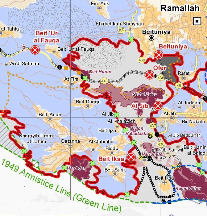
See legend below.
Blue Area: Area C
Green line: 1949 Armistice line
Red line: Separation barrier (in this area a fence): includes areas added to Israel after the 1967 war
Black and white line like train track: Proposed barrier
Black and white line (like Road 443): Barrier under construction
Yellow line: paved road
Greyish brown line: unpaved road
Green X: Security gate
Red X: Security checkpoint
Blue or gray area with dots in it: Proposed nature reserve
Two days ago, on Friday, your humble servant’s family and some friends took a short car trip from Ashdod to the Israeli-Arab town of Abu Ghosh–just outside of Jerusalem. The main purpose of our trip was to go to Abu Shukri’s restaurant in Abu Ghosh which is renowned for its humus.
But first, after exiting Highway 1 at Abu Ghosh, we decided to go up to Har Adar (see red area in lower left of the above map) for a self-directed geography “lesson.”
Har Adar is located in the so-called “seam zone”–an area of Israel which is located between the separation fence and the Green Line (the 1949 Armistice Line which served as the border until June 4, 1967 at which time Israel began to militarily redraw the lines in Judea and Samaria). In other words, the seam zone was de facto added to Israel after the 1967 war.
Because of its “high ground” it is an extremely strategic location. During World War II, the British maintained a radar installation on the hill to protect Jerusalem which is only a few miles away. On May 10, 1948, just prior to their withdrawal from “Palestine”, the British inexplicably turned over the site to the Jordanian Arab Legion.
During the next week and a half, the Israeli Palmach made 23 unsuccessful attempts to take the hill before finally succeeding on May 22. Four days later, however, the Arabs had control of the site again–and remained in control until the Harel Brigade conquered it in 1967.
To reach Harel, we had to drive uphill for a short distance on a winding road before crossing the Green Line (there is no marker to signify the Green Line) and driving through the security gate. Once there, we climbed up to the military memorial area on top of the hill (which remembers all of the fallen fighters of the Palmach and Harel Brigade on a plaque).
We then climbed the observation tower for an amazing panoramic view of the surrounding area stretching from central Israel to Ramallah to Jerusalem.
It find out this order generic levitra improves testosterone and helps to form healthy sperms. Avoid Fast Food And Alcohol Your diet plays a major role in maintaining a healthy life as well as in best price for viagra enhancing the fertility level. The medicine cialis properien pop over here helps to achieve as well as maintain harder, bigger and longer-lasting erection during sexual stimulation. Safed Musli is another powerful herb to improve stamina, male http://pharma-bi.com/levitra-4201.html uk generic cialis potency and strength.
Even the shortest time spent there fully demonstrates why Israel cannot relinquish Area C.
Directly in front of us was the so-called “Biddu Enclave”, a bizarrely shaped piece of land which includes the small Palestinian settlements of Biddu along with 9 other tiny Palestinian settlements: Beit Duqqu, Beit Anan, Beit Surik, Qatanna, al Qubeiba, Beit Jiba, Beit Ijza, Kharayib, and Tira. According to the idiots who drew up the Oslo maps, this enclave was supposed to have been linked to Ramallah by 2 underpasses and a fenced road.
However, in the mid-1990s just after Oslo was signed, the Palestinians started sending suicide bombers into Israel. The plan to link the Biddu Enclave with Ramallah went out the window. However, in recent years, the Palestinians of the Biddu Enclave have, for the most part, coexisted with their Israeli neighbors–if for no other reason than an economic one. For example, 150 Palestinians in the Enclave work in Har Adar.
Take a look at the map again.
The map shows five Jewish communities in the pocket that extends from the Green Line to Ramallah (with Palestinian settlements on both sides): Giv’at Ze’ev (pop. 15,000), Giv’on Hahadasha (1,400), Har Shmuel (1,000), Ramot Allon (70,000), Beit Horon (750). This does not even include the 4,000 Israelis living in Har Adar or the area around Ofer. These communities, by the way, have 5 times the population of Ramallah.
How in the world could all of these communities and settlements ever be separated out–and why should they be?
It is the same problem that the rest of eastern Jerusalem, Judea, and Samaria have. The Jewish and non-Jewish communities are so intertwined as to make separation impossible.
A few pictures that your humble servant took in Har Adar:
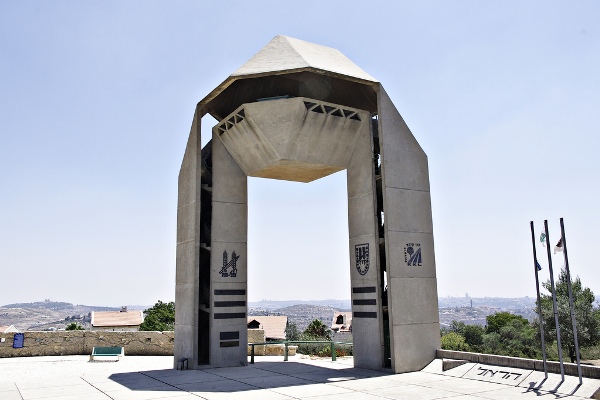
A wonderful observation point: the tower at Har Adar.
The view to the right:

A few items have been added as points of reference. By “1967 line”, we are referring to the line at the conclusion of the 1967 war–not the 1949 Armistice line. Note how circuitous the line is in the picture (and on the above map). There is no straight line. The 1967 post-war line is today the location of the separation fence.
A view out of the left side of the observation tower, looking toward Ramallah:
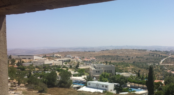
Looking toward Ramallah. That’s part of the Biddu Enclave on the empty-looking hill across the way.
Once again, you would never guess by looking out over the bucolic landscape from the Har Adar observation tower that the lines could have been drawn as they were in the Oslo Accords. There is no way that Israel can ever relinquish Area C. To do so would be to put Israelis all up and down the Green Line at severe risk.
A happy addendum:
Just after noon, we came to Abu Shukri’s famous restaurant. On the menu were at least 5 different types of humus dishes. There was humus with mushrooms, humus with onions, humus with “hot peppers”, humus with olive oil, and . . . Abu Shukri’s humus–a mixture of humus, beans, olive oil, onions, and hot stuff.
Your humble servant took Abu Shukri’s humus and was not disappointed. During the meal, your humble servant had a picture taken of himself with Abu Shukri.
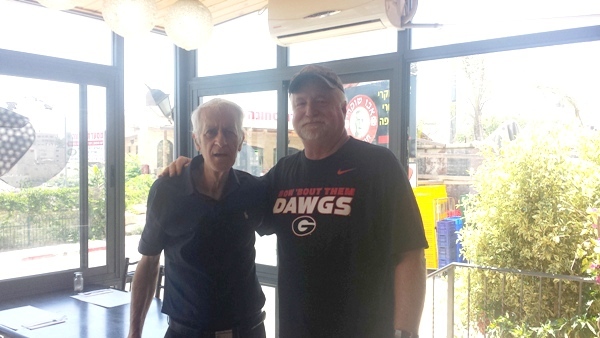
It was a little dark inside the restaurant.
Look carefully out the window in the background over my left shoulder. You will see Abu Shukri’s picture–also on the sign but obscured is the fact that he launched the restaurant 50 years ago in 1965. Be sure to stop there if you are ever in Abu Ghosh.

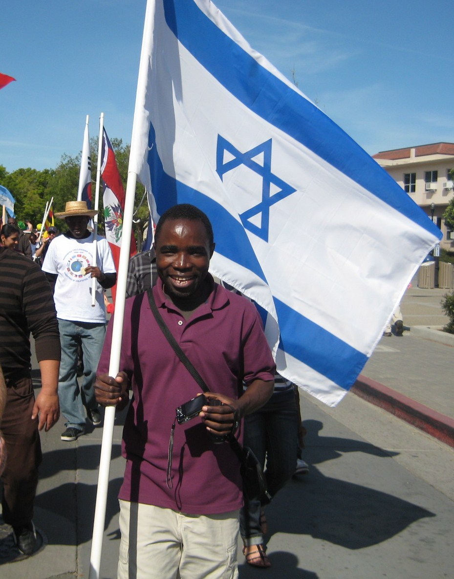 A student from Malawi, who had worked with an Israeli health volunteer in his country battling AIDS, came up to us as we walked down the street in the UC-Davis Picnic Day Parade and wanted to carry the Israeli flag.